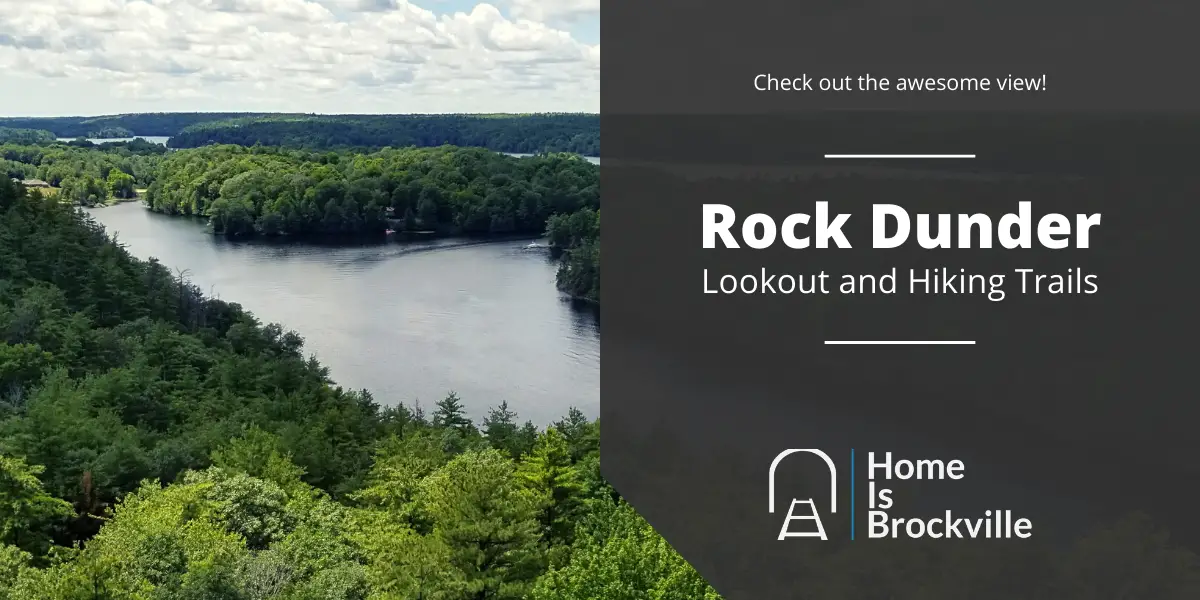
The Rock Dunder Hiking Trail is home to the highest lookout point in the Kingston area. The trails offer excellent hiking, suitable for everyone including kids and dogs.
The best park about hiking Rock Dunder is definitely the rewarding views at the highest point in the trail. Check it out!
What is Rock Dunder?
Rock Dunder is 230-acres of wilderness and hiking trails located in the UNESCO Thousand Islands Frontenac Arch Biosphere Reserve. The site used to be owned by Scouts Canada for around 40 years. Rock Dunder was purchased by the RWLT in 2006.
The main feature of Rock Dunder of course is the amazing 360 degree view of Morton Bay. Made possible by the incredible rock formation located at just about the halfway point of the loop trail.
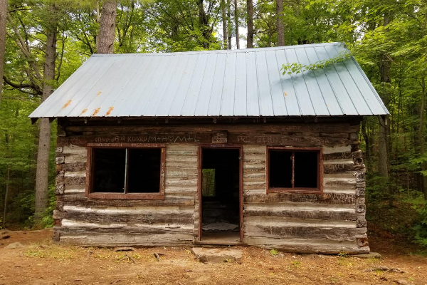
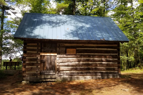
Three trails take you through the beautiful wilderness of the nature reserve all the way up the rock and back down the other side. Passing by lakes, beaver ponds and creepy rustic cabins.

Recent Posts
- Brockville Municipal Elections 2022: How and Where To Vote
- Brockville and Area Home Sales Data – Week 18 2022
- Rock Dunder Hiking Trail: Beautiful Lookout, Rustic Cabins, Cliff Jumping
- Dash Delivers Brockville: How To Order and How To Earn Money Driving
- Legal Cannabis Brockville: Where To Buy, How To Enjoy The Right Way
How To Get To Rock Dunder
It’s not hard to get to the entrance of the trail, you’ll know you are there when you see all of the cars parked on the side of the road.
Address for Google Maps: 72 Stanley Lash Ln, Lyndhurst, ON K0E 1N0
Click here for Google Map directions to Rock Dunder.
Rock Dunder is easily accessible from Kingston, Gananoque, Brockville, and Ottawa.
Directions from Brockville
The trip to Rock Dunder from Brockville will take you about 45 minutes.
- Take Highway 29 out of town and take the Athens turn off.
- From Athens follow County Road 42 all the way to the turn off for County Road 33.
- Once in Lyndhurst take the turn for Old Briar Hill Road and follow Briar Hill to Highway 15.
Rock Dunder is not much further South on Highway 15 you can’t miss it. But just in case, here is a map!

Where can you park?
There are two parking lots on site and each holds about 14 cars. Parking is included with your $10 entry fee if you do find a spot on the hiking trail property.
On busy days when the parking lots are full, you may need to park on the side of Highway 15. Make sure you don’t park where the “No Parking” signs are, you may be ticketed or towed.
There is also a tiny parking lot just across from the entrance to Stanley Lash Lane.

About The Rock Dunder Trails
Rock Dunder technically has 3 trails, but two of the trails join together to create the loop that takes you to the summit.
The Summit Loop Trail and the Cabin Trail merge together to form a loop. This is the hiking trail you will take to get to the famous lookout point of the area. The lookout is almost at the midway point of the loop.
The third trail is the Morton Bay Trail and is also connected to the Cabin and Summit trails.
To access both trails you will need to purchase a day pass or use your season pass.

How To Get A Day Pass To The Trails
To make use of the trails at Rock Dunder you will need to purchase a day pass from the Rideau Waterway Land Trust. A day pass will grant you admission to the trails from sunrise to sunset.
The fee for the day pass is $10 and can be purchased either online at Eventbrite or at the trailhead.
If you are purchasing at the trailhead, you can use cash, debit, or credit to purchase your day pass.
For those who want to revisit the rock there is the season pass, which will cost you $50. This will give you (and your group) access to the park all season long.
The Summit Loop Trail and The Cabin Trail
Difficulty: Moderate
Length: 4.2km
Time: 1.5-3 hours
Elevation Gain: 91 meters
The Summit Loop trail is the longest trail and this is the hiking trail that will lead you to incredible views!
The entrance
After you park, you will head up the road to the entrance of the park. There is a trailer and there will be a RWLT team member there to check either your online tickets or collect your entrance fee.

Once you’re in it’s time to hit the trails, follow the path until you come to the fork. You can either take the trail counter clockwise or clockwise.
The Summit Loop and the Cabin trails together create the loop that most hikers take. There is a secondary loop called Morton Bay Trail that is accessible from the Cabin Trail.
Starting the Summit Loop Trail
At the fork, heading south takes you on the Summit Loop trail, from here it is about 2km to the rock summit.

Follow the trail markers
The trail to the rock is well defined and leads you through the wonderful wilderness of the Frontenac Biosphere. Just follow the yellow triangles and you’ll be fine!

On the way you’ll pass by boardwalks and beaver dams, closer to the middle is where it starts to get a little rocky. The trail itself is still pretty user friendly.

How about those views
Once you pass the beaver dam it is not far before the trail starts leading up. This is where the views everyone talks about make an appearance.

Keep following the views until you make it to the clearing, you’ll know you are there when you see a ton of people taking photos.

Time to head out
When you are done taking in the breathtaking views of the surrounding lakes and woodlands, it’s time to head back to the trail. You can either go back the way you came or take the Cabin trail back to the entrance.
Heading back from the rock on the Cabin trail can be a little challenging for some people. Just before the first cabin is a steep rocky hill that needs to be traversed to make it to the bottom. There are plenty of trees and rocks to hold on to along the way.

Enjoy the lake
You’ll find some benches a long this path that look out onto Whitefish Lake and Morton Bay. There are also areas to swim and cliff jump along this trail.

Once you make it back to the gravel trail you are on your way out. Eventually you will reconnect with the entrance to the Summit Loop Trail. Keep heading straight to exit the park.

What’s the story with the cabins?
The land around Rock Dunder used to be owned by the Scouts Canada but was purchased by the Rideau Waterway Land Trust in 2006. The cabins are left over from Scouts Canada and are super fun to explore!
Is there swimming
Yes! You can take a break from your hike and have a dip in whitefish lake. There are spots to get in along the part of the trail that follows Morton Bay and Whitefish Lake.
There is even a spot to go cliff jumping at Rock Dunder!
Photos
Here are some more breathtaking images of Rock Dunder.
Drone video
While the views from the top of the rock are incredible, a birds eye view of Rock Dunder is just as remarkable.
These videos of Rock Dunder taken with drones give you a full 360 degree view of the area.
FAQ
Rock Dunder is managed and owned by the Rideau Waterway Land Trust.
Phone: 613-305-3507
Email: rwlt.email@gmail.com
Website: www.rwlt.org
There are no camp sites and there are no overnight stays at Rock Dunder. Nearby campsites include Shady Ridge Campgrounds, Knapp’s Brass Point Camping, and Singleton Lake Family Campground.
You can most definitely bring your furry friend, but they must remain on leash while on the RWLT property.
Yes, you should wear bug spray or long pants to prevent ticks while hiking. It is also a good idea to check yourself for ticks once the hike is over.
The RWLT opens Rock Dunder on May 15th and closes the trails on November 15th. The trail hours are from sunrise to sunset everyday during that period.
Rock Dunder is closed from November 16th to May 14th, access is off limits to the public during this time.
Yes! There is an outhouse located at the beginning of the trails. Once on the trail it is just you and the great outdoors! Pack it in Pack it out.